Kategorie

Größe dieser Vorschau: 800 × 555 Pixel. Weitere Auflösungen: 320 × 222 Pixel | 640 × 444 Pixel | 1.024 × 710 Pixel | 1.245 × 863 Pixel.
Originaldatei (1.245 × 863 Pixel, Dateigröße: 612 KB, MIME-Typ: image/jpeg)
Beschreibung
| Beschreibung |
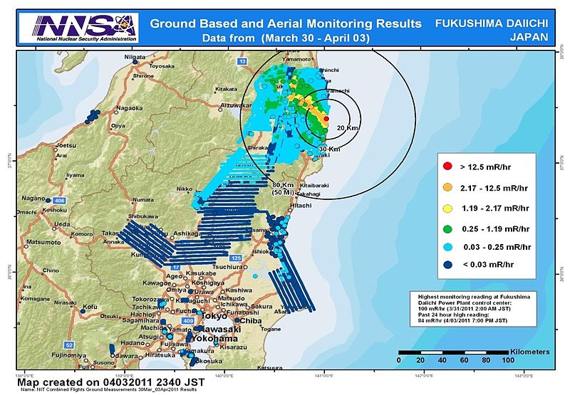
English: Combined results of 211 flight hours of aerial monitoring operations and ground measurements made by DOE, DoD and Japanese monitoring teams. |
| Datum | |
| Quelle | 4th slide of http://energy.gov/news/documents/AMS_Data_April_4__v1.pptx available at http://blog.energy.gov/content/situation-japan |
| Urheber | National Nuclear Security Administration (NNSA) US Department of Energy |
| Andere Versionen |
|


Lizenz
| This image is a work of a United States Department of Energy (or predecessor organization) employee, taken or made as part of that person's official duties. As a work of the U.S. federal government, the image is in the public domain.
Please note that national laboratories operate under varying licences and some are not free. Check the site policies of any national lab before crediting it with this tag.
|

|
Dateiversionen
Klicke auf einen Zeitpunkt, um diese Version zu laden.
| Version vom | Vorschaubild | Maße | Benutzer | Kommentar | |
|---|---|---|---|---|---|
| aktuell | 09:36, 9. Apr. 2011 | | 1.245 × 863 (612 KB) | wikimediacommons>Teofilo | cropped |
Dateiverwendung
Die folgende Seite verwendet diese Datei: