Kategorie
Größe dieser Vorschau: 800 × 400 Pixel. Weitere Auflösungen: 320 × 160 Pixel | 640 × 320 Pixel | 1.434 × 717 Pixel.
Originaldatei (1.434 × 717 Pixel, Dateigröße: 1,5 MB, MIME-Typ: image/png)
Beschreibung
| Beschreibung |
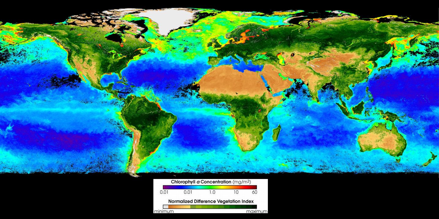
English: SeaWiFS Global Biosphere, Visualization Date 2002-08-03
This composite image gives an indication of the magnitude and distribution of global primary production, both oceanic (mg/m3 chlorophyll a) and terrestrial (normalized difference land vegetation index). Provided by the SeaWiFS Project, NASA/Goddard Space Flight Center and ORBIMAGE. Primary source: http://visibleearth.nasa.gov/view_rec.php?id=3435 |
| Datum | |
| Quelle | http://visibleearth.nasa.gov/view_rec.php?id=3435 |
| Urheber | Yikrazuul |
| Andere Versionen |
 |
Lizenz
| This image is from the Sea-viewing Wide Field-of-view Sensor (SeaWiFS) Project and more than 5 years old.
Satellite data captured by the SeaWIFS sensor are released into the public domain 5 years after capture. Data less than five years old can be re-used only for educational or scientific purposes; any commercial use of such images must be coordinated with GeoEye. [1] |
| This work has been released into the public domain by its copyright holder, GeoEye. This applies worldwide. In manchen Staaten könnte dies rechtlich nicht möglich sein. Sofern dies der Fall ist: GeoEye gewährt jedem das bedingungslose Recht, dieses Werk für jedweden Zweck zu nutzen, es sei denn, Bedingungen sind gesetzlich erforderlich.
|
Dateiversionen
Klicke auf einen Zeitpunkt, um diese Version zu laden.
| Version vom | Vorschaubild | Maße | Benutzer | Kommentar | |
|---|---|---|---|---|---|
| aktuell | 23:02, 14. Sep. 2009 | | 1.434 × 717 (1,5 MB) | wikimediacommons>Yikrazuul | {{Information |Description={{en|1=SeaWiFS Global Biosphere September 1997 - August 1998 This composite image gives an indication of the magnitude and distribution of global primary production, both oceanic (mg/m3 chlorophyll a) and terrestrial (normalize |
Dateiverwendung
Die folgende Seite verwendet diese Datei: